Lake News Alerts
We'd like to send you lake news articles, videos, and podcasts from around the web.
 We will never share your email
|
Lakes in Alabama, United States
Alabama has no large natural lakes, but dams built on the abundant rivers have created many artificial lakes.
MAJOR LAKES
|
|

|
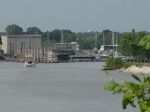
Aliceville Reservoir, sometimes called Pickensville Lake, is an 8,300-acre reservoir with public bank / boat access areas, modern and primitive campgrounds, and many day-use facilities. This lake has an excellent tailwater fishery for catfish, crappie, bass, and drum. Bluegill and redear sunfish are very abundant.
Aliceville reservoir is formed ...
|
|
|
|
|
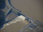
Bankhead Reservoir contains 9,200 acres and is the second largest lake on the Warrior River. Located approximately 15 miles west of Birmingham and 30 miles northeast of Tuscaloosa, Bankhead Reservoir flows through Walker, Jefferson and Tuscaloosa Counties. The primary uses for this reservoir are navigation, hydroelectric generation, flood control, ...
|
|
|
|
|
Claiborne Lake is a river-run reservoir with 5,930 surface acres of water which courses 60.5 miles through Wilcox, Clarke, and Monroe counties in southwest Alabama. This reservoir was constructed by the U.S. Army Corps of Engineers and impounded in 1970. Claiborne Lake has a large watershed of 21, 473 square miles, and its primary function is navi...
|
|
|
|
|
Coffeeville Reservoir is an 8,500-acre U.S. Army Corps of Engineers impoundment located on the Tombigbee River. Coffeeville Reservoir extends 97 miles from Demopolis, Alabama, to the dam, which is located approximately 3 miles from the town of Coffeeville. Boating access is available along the reservoir operated by the Corps of Engineers, Alabama W...


Full Pool: 32.5 MSL
Area: 8,800 Acres
|
|
|
|
Demopolis Reservoir is a 10,000-acre reservoir located near the City of Demopolis in Marengo County. Demopolis Lake is downstream of the towns of Eutaw in Greene County on the Warrior River and Gainesville on the Tombigee River. This reservoir is the second largest lake in the Black Warrior-Tombigbee system. The lake extends 48 miles upriver on the...
Full Pool: 73.0 MSL
Area: 10,000 Acres
|
|
|

|
Walter F. George Lake (Lake Eufaula) is a 45,000 acre lake located on the Chattahoocee River between the states of Alabama and Georgia. This area is rich in history with many nearby historic sites and towns. The lake is nationally known for it's bass and crappie fishing. The lock, located at Ft. Gaines, Georgia, has the second highest drop east of ...
|
|
|

|
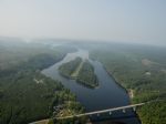
Lake Guntersville is located in north Alabama between Bridgeport and Guntersville. Alabama's largest lake contains 69,100 acres and stretches 75 miles from Nickajack Dam to Guntersville Dam. Free boat ramps and private marinas dot the lake's perimeter. Fishing, boating, camping, hunting and eagle watching are popular sports in the area. Eagle watch...
|
|
|
|
Lake Harding, Ga | Lake Harding, Al., also known as Bartlett's Ferry Lake, is a 5,850-acre reservoir on the Chattahoochee River and is formed by Bartlett's Ferry Dam. Lake Harding is just north of Columbus, Ga. and east of Auburn, Al.
Rev. Simpson Wilson Bartley operated a ferry known as Bartley's Ferry on the Chattahoochee River and in 1926, B...
Full Pool: 521.0 MSL
Area: 5,860 Acres
|
|
|
|
Located twenty-five miles due north of the city of Montgomery in central Alabama, Lake Jordan is a 6,800-acre impoundment on the Coosa River with 188 miles of shoreline. The Mitchell Dam tailwater area at the upper end of the lake is a popular recreational area to many anglers with ample bank fishing access. Lake Jordan was impounded by Alabama Pow...
|
|
|

|
Lay Lake is a 12,000-acre reservoir located thirty-five minutes south of Birmingham off I-65 and fifteen miles south of Columbiana in east-central Alabama. Lay Lake borders St. Clair, Talladega, Shelby, Coosa, and Chilton Counties. The primary uses for this reservoir are hydroelectric generation and recreation. Lay Lake is popular for tournament ...
|
|
|

|
Logan Martin Lake is located on the Coosa River in east-central Alabama approximately 30 miles east of Birmingham, Alabama. This 17,000 acre Coosa River reservoir was built in 1965 by Alabama Power Company. Nicknamed "Lake of a Thousand Coves" by locals, Logan Martin has 275 miles of shoreline along its 48.5 mile length sandwiched between Logan Ma...
|
|
|

|
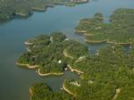
Lake Martin is a man-made reservoir located in Tallapoosa, Elmore and Coosa counties in Alabama on the Tallapoosa River. It was formed by the construction of Martin Dam on the Tallapoosa River. The Martin Dam powerhouse is used to generate hydroelectric power for the Alabama Power Company. Construction on Martin Dam began in 1923 and was completed ...
|
|
|
|
Located just off I-65 and ten miles due east of the city of Clanton in central Alabama, Lake Mitchell is a 5,850-acre impoundment on the Coosa River with 147 miles of shoreline. The Lay Dam tailwater area at the upper end of the lake is a popular recreational area to many anglers with ample bank fishing access. Impounded by Alabama Power in 1922, a...
|
|
|
|
Neely Henry Reservoir is located in northeast Alabama on the Coosa River, near the towns of Gadsden and Ohatchee. Just off I-59, the reservoir envelops 11,235 acres and extends 77.6 miles from the dam upstream to Weiss dam. Generally a river-run lake, Neely Henry fans out toward the dam to offer more open water. Sandwiched between Weiss Lake (a.k.a...
|
|
|

|
Pickwick Lake has often been called the best trophy smallmouth fishery in the country. This is due in large part to the numerous beneficial conditions of the river system and its location. The lake is situated at the southern boundary of habitable climate for smallmouth. This southern location allows for a longer growing year, which produces lar...
|
|
|
|
|
Jones Bluff Reservoir (also known as R. E."Bob" Woodruff Lake) impounds the Alabama River between Montgomery and Selma in central Alabama. The Army Corps of Engineers built the Robert F. Henry Lock and Dam to create a 12,510 acre reservoir that provides navigation, hydroelectric power generation, and recreation. Jones Bluff is a riverine impoundmen...
|
|
|
|
Lewis Smith Lake (or Smith Lake) is located in North-Central Alabama about 20 miles northwest of Birmingham in state of Alabama (U.S.) counties of Cullman, Walker and Winston. The 300-foot high dam, completed in 1961 by Alabama Power Company, impounds the Sipsey Fork of the Black Warrior River to form the lake. Smith Lake has a surface area of 21,2...
|
|
|
|
|
Located five miles north of the cities of Tuscaloosa and Northport in west central Alabama, Lake Tuscaloosa is a 5,885-acre water supply reservoir with 177 miles of shoreline. The tailwater area (North River) drains into the Black Warrior River basin and is a popular recreational area to many anglers. When the reservoir was impounded by the City of...
|
|
|
|
|
Warrior Lake, located six miles from Eutaw, AL, has a surface area of 7,800 acres and a length of 77 miles. Armistead I. Selden Lock and Dam was completed in 1962. Facilities on the lake include primitive camping, boat launching and day use.
Mound State Monument is located on the lake at mile 303.4. Forty Indian temple mounds rise from a bluff o...
|
|
|
|
The lake was created by the flooding of the plains behind the Harris Dam, which began construction on November 1, 1974. The last part of construction of the dam ended on April 20, 1983.
There are many recreational attractions on Lake Wedowee such as boating, swimming, fishing and camping. Fishing brings the most attraction to the lake. It is kn...
|
|
|
|
Lake Weiss (pronounced "Wice") is an Alabama Power Company hydroelectric impoundment covering 30,200 acres in northeast Alabama on the Alabama - Georgia border. The Weiss Lake fishery is the major economic influence in Cherokee County, so the locals treat anglers very well. Four free public access areas and 37 privately run marinas service Lake Wei...
|
|
|

|
Surrounded by deep forests and rolling fields, West Point Lake extends 35 miles along the Chattahoochee River on the Alabama-Georgia state line. The lake's 500 miles of shoreline provides excellent opportunities for fishing, camping, boating and other recreational activities.
The construction of West Point Dam was authorized by the Flood Control A...
|
|
|

|
Wheeler Lake is the second-largest lake on the Tennessee River in Northern Alabama, second only to Guntersville Lake, its immediate upstream neighbor. Wheeler Lake is also bordered by Wilson Lake on its downstream side. The lake was constructed by the Tennessee Valley Authority just prior to World War II as a means of hydroelectric generation and f...
|
|
|
|
|
Millers Ferry is a 17,200-acre reservoir on the Alabama River impounded by the U.S. Army Corps of Engineers in 1969. The official name of this impoundment is William (Bill) Dannelly Reservoir; however, it is better known locally as "Millers Ferry." There are numerous public access areas located on the reservoir. Camping facilities are available at ...
|
|
|
|
An impoundment of the Tennessee River, Wilson Lake was formed by the creation of Wilson Dam, which separates Wilson Lake from its downstream neighbor, Pickwick Lake. Wilson Lake features healthy populations of numerous game fish, including largemouth bass, smallmouth bass and crappie.
Visitors to Wilson Lake are able to enjoy the benefits of ...
|
|
|
|
OTHER LAKES IN ALABAMA
(alphabetical)
|
|
Lake Name
|
Full Pool *
(MSL) **
|
Acres
|
River
|
Map
|
|
Andrews
|
105.0
|
1,540
|
Chattahoochee River
|
|
|
Bear Creek
|
|
670
|
|
|
|
Bibb County
|
|
|
|
|
|
Big Creek
|
|
3,600
|
Escatawpa River
|
|
|
Bounds
|
|
|
|
|
|
Caldwell
|
509.0
|
|
|
|
|
Catoma
|
742.0
|
536
|
|
|
|
Cedar Creek
|
|
4,200
|
Tennessee River
|
|
|
Chambers County
|
|
|
|
|
|
Choccolocco
|
|
|
|
|
|
Clay County
|
|
|
|
|
|
Coffee County
|
|
|
|
|
|
Coopers
|
|
|
|
|
|
Dale County
|
|
|
|
|
|
Dallas County
|
|
|
|
|
|
DeKalb County
|
|
|
|
|
|
Double Oak
|
|
|
|
|
|
Fayette County
|
|
|
|
|
|
Finger
|
|
|
|
|
|
Four Wing
|
|
|
|
|
|
Gainesville
|
|
|
Tennessee-Tombigbee Waterway
|
|
|
Gantt
|
|
2,767
|
Little Conecuh River
|
|
|
Gateway
|
|
|
|
|
|
Geneva County
|
|
|
|
|
|
Gerald
|
|
|
|
|
|
Goat Rock
|
404.0
|
940
|
Chattahoochee River
|
|
|
Great Pine
|
|
|
|
|
|
Harris
|
|
|
|
|
|
Hillhouse
|
|
|
|
|
|
Hollybrook
|
222.0
|
|
|
|
|
Holt
|
187.0
|
3,296
|
Black Warrior River
|
|
|
Howard
|
|
180
|
|
|
|
Indian Estates
|
|
|
|
|
|
Indian Valley
|
|
|
|
|
|
Inland
|
|
1,536
|
Black Warrior River
|
|
|
Jackson
|
|
1,037
|
|
|
|
Lamar County
|
|
|
|
|
|
Lee County
|
|
|
|
|
|
Leon Brooks Hines
|
|
184
|
|
|
|
Little Bear
|
|
1,560
|
|
|
|
Lunker
|
|
|
|
|
|
Lurleen
|
|
250
|
|
|
|
Madison County
|
|
|
|
|
|
Marion County
|
|
|
|
|
|
Monroe County
|
|
|
|
|
|
Mountain View
|
|
|
|
|
|
Oak Mountain
|
|
|
|
|
|
Oliver
|
337.0
|
2,150
|
Chattahoochee River
|
|
|
Pike County
|
|
|
|
|
|
Pine Ridge
|
|
25
|
|
|
|
Purdy
|
|
|
|
|
|
Shady Grove
|
|
|
|
|
|
Tallassee
|
288.8
|
585
|
Tallapoosa River
|

|
|
Tholocco
|
|
680
|
|
|
|
Upper Bear
|
|
1,850
|
|
|
|
Upper State
|
|
105
|
|
|
|
Valley
|
|
|
|
|
|
Virginia
|
|
|
|
|
|
Walker County
|
|
|
|
|
|
Washington County
|
|
|
|
|
|
Wehapa
|
|
|
|
|
|
William Baker Oliver
|
|
2,150
|
Black Warrior River
|
|
|
Yates
|
344.0
|
1,980
|
Tallapoosa River
|
|
|
Yielding
|
|
|
|
|
* Full Pool - Highest normal summer pool level before flood stage
** MSL - Mean (average) feet above sea level
|
|