Lake News Alerts
We'd like to send you lake news articles, videos, and podcasts from around the web.
 We will never share your email
|
Lakes in Tennessee, United States
MAJOR LAKES
|
|

|
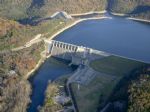
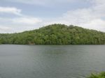
Lake Barkley, a 58,000-acre (230 km2) reservoir in Livingston, Lyon, and Trigg counties in Kentucky and extending into Stewart and Houston counties in Tennessee, was impounded by the U.S. Army Corps of Engineers in 1966 upon the completion of Barkley Dam. Both the lake and the dam are named for Vice President Alben Barkley, a Kentucky native. The d...
|
|
|
|
Center Hill Lake is a reservoir located in Middle Tennessee near Smithville. Created by the U.S. Army Corps of Engineers in 1948, the lake has two purposes: electricity production and flood control.
...
|
|
|
|
|
Cheatham Lake is an impoundment of the Cumberland River with 320 miles of shoreline. Recreational opportunities include boating, fishing, camping, picnicking, swimming, canoeing, and others. Trails at the lake will captivate bird watchers, wildflower enthusiasts, nature lovers, hikers, horseback riders, and bicyclists. Fishing is great with popular...


Full Pool: 385.0 MSL
Area: 7,450 Acres
|
|
|
|
Water Source - A TVA impoundment of the Holston River constructed in 1943 to provide hydroelectric power, flood control and recreation. Major tributaries include Poor Valley, Ray and German creeks.
Water - Fertile and often stained from muddy runoff, or algae that produces a greenish tint. The thermocline develops in April and is most pronounc...
|
|
|
|
Chickamauga Lake is a reservoir along the Tennessee River created when the Chickamauga Dam, as part of the Tennessee Valley Authority, was completed in 1940. The lake stretches from Watts Bar Dam at mile 529.9 (853 km) to Chickamauga Dam at mile 471.0 (758 km) making the lake 58.9 miles (94.8 km) long. It borders Rhea County, Meigs County, and Hami...
|
|
|

|
Cordell Hull Lake is named after one of America's outstanding statesmen, Cordell Hull. Cordell Hull was born in a log cabin in the foothills of the Cumberland Mountains.
Hull served in the Tennessee and U.S. House of Representatives and in the U.S. Senate. He served as Secretary of State under President Franklin D. Roosevelt from 1933 to 1944 ...
Full Pool: 504.0 MSL
Area: 11,960 Acres
|
|
|
|
LAKE PROFILE
Size & Depth - 30,400 acres with a maximum depth of 140 feet. The lake extends 43.1 miles upstream from the Douglas Dam.
Water Source - An impoundment of the French Broad River completed in 1943. The Nolichucky and Pigeon rivers are the primary tributaries, and there are numerous small inlet creeks.
During rainy seasons, it ...
|
|
|

|
Fort Loudoun Reservoir, located on the Tennessee River at Knoxville, is the uppermost in the chain of nine TVA reservoirs that form a continuous navigable channel from there to Paducah, Kentucky, 652 miles away.
Fort Loudoun Reservoir takes its name from the 18th-century British fort built on a nearby site during the French and Indian War. The f...
|
|
|
|
|
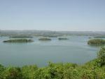
Kentucky Lake is a major navigable reservoir along the Tennessee River in Kentucky and Tennessee. Created in 1944 by the Tennessee Valley Authority's impounding of the Tennessee River by Kentucky Dam, the 160,309-acre (649 km2) lake is the largest artificial lake by surface area in the United States east of the Mississippi River (though not the lar...
|
|
|
|
Melton Hill Lake provides nearly 193 miles of shoreline and 5,470 acres of water surface and includes parts of Loudon, Roane, Anderson, and Knox counties. The reservoir stretches 56 miles up the Clinch from the dam to the base of Norris Dam, and is navigable for 38 miles from Melton Hill Dam to Clinton. Melton Hill is the only TVA dam on a tributar...
Full Pool: 794.0 MSL
Area: 5,690 Acres
|
|
|
|
Nickajack Lake is the reservoir created by Nickajack Dam as part of the Tennessee Valley Authority. The lake stretches from Nickajack Dam north to Chickamauga Dam and runs along the shores of Chattanooga, Tennessee. The stretch of the Tennessee River commonly referred to as the "Grand Canyon of Tennessee" also is part of Nickajack Lake.
Full pool ...
|
|
|
|
Norris Lake was created by the construction of Norris Dam in the mid-1930s. Norris Dam was the first major project for the Tennessee Valley Authority, which had been created in 1933 to bring economic development to the region and control the rampant flooding that had long plagued the Tennessee Valley. The dam was named in honor of Nebraska Senator ...
|
|
|

|
Old Hickory Lake is a reservoir in north central Tennessee. It is formed by the Old Hickory Lock and Dam, located on the Cumberland River approximately 25 miles upstream from Nashville. The city of Hendersonville is situated on the northern side of the lake, and Old Hickory, is located on the southern side of the lake. The dam and lake are named af...
|
|
|
|
|
Percy Priest Lake is a reservoir in north central Tennessee. It is formed by J. Percy Priest Dam, located about 10 miles east of downtown Nashville. The lake and dam are named for Congressman Percy Priest.The dam project was first authorized by an act of Congress approved on July 2, 1958. The U.S. Army Corps of Engineers project was completed in 19...
|
|
|

|
Pickwick Lake has often been called the best trophy smallmouth fishery in the country. This is due in large part to the numerous beneficial conditions of the river system and its location. The lake is situated at the southern boundary of habitable climate for smallmouth. This southern location allows for a longer growing year, which produces lar...
|
|
|
|
|
Reelfoot Lake is a shallow natural lake located in the northwest portion of Tennessee. Much of it is more of a swamp, with bayou-like ditches connecting basins, the largest of which is called Blue Basin. Reelfoot Lake is noted for its bald cypress trees and its nesting pairs of bald eagles, and is the site of Reelfoot Lake State Park.
...
|
|
|
|
|
Tims Ford Lake is a reservoir run by the Tennessee Valley Authority in southern middle Tennessee.
Tims Ford Dam was built by the TVA from 1966 to 1970, stands 175 feet high and 1580 feet long at its crest, and impounds the Elk River for an average of 36 megawatts of hydroelectric power. The reservoir has a flood storage capacity of 219,600 acre-...
|
|
|
|
Located about midway between Chattanooga and Knoxville, the lake begins as the Tennessee River below Fort Loudon Dam in Lenoir City, Tennessee and stretches 72.4 miles (116.5 km) to Watts Bar Dam, near Spring City, Tennessee.
The Clinch River connects to the main channel of the lake at mile 568 near Southwest Point in Kingston, Tennessee. The ...
|
|
|
|
OTHER LAKES IN TENNESSEE
(alphabetical)
|
|
Lake Name
|
Full Pool *
(MSL) **
|
Acres
|
River
|
Map
|
|
Beech
|
|
|
|
|
|
Bennett
|
|
|
|
|
|
Boone
|
1,382.0
|
4,510
|
Holston River
|
|
|
Browns
|
|
|
|
|
|
Calderwood
|
|
541
|
Little Tennessee River
|
|
|
Campbell Cove
|
|
71
|
|
|
|
Candlewood
|
|
|
|
|
|
Canterbury
|
|
47
|
|
|
|
Carroll County
|
|
1,000
|
|
|
|
Chilhowee
|
|
1,734
|
Little Tennessee River
|
|
|
Coleman
|
|
|
|
|
|
Coro
|
|
95
|
|
|
|
Crest
|
740.0
|
|
|
|
|
Cummings
|
|
|
|
|
|
Dale Hollow
|
651.0
|
2,700
|
|

|
|
Dweller
|
760.0
|
|
|
|
|
Eagle
|
|
20
|
|
|
|
Fort Patrick Henry
|
1,263.0
|
872
|
|
|
|
Grand Valley
|
|
102
|
|
|
|
Great Falls
|
|
1,830
|
Caney Fork
|
|
|
Holiday
|
|
225
|
|
|
|
Horn
|
|
1,200
|
Mississippi River
|
|
|
Indian Rock
|
|
19
|
|
|
|
Lakewood
|
|
12
|
|
|
|
Laurel Mountain
|
|
51
|
|
|
|
Lincoln
|
|
40
|
|
|
|
Logan
|
|
38
|
|
|
|
Normandy
|
865.0
|
2,490
|
Duck River
|
|
|
Parksville
|
|
1,930
|
|
|
|
Pine
|
|
15
|
|
|
|
Raccoon Mountain
|
|
80
|
|
|
|
Radnor
|
|
82
|
|
|
|
Robco
|
|
277
|
|
|
|
South Holston
|
1,729.0
|
4,860
|
|
|
|
Tansi
|
|
630
|
|
|
|
Tellico
|
813.0
|
18
|
Little Tennessee River
|
|
|
Tullahoma
|
|
35
|
Elk River
|
|
|
Watauga
|
1,959.0
|
4,690
|
|
|
|
Woods
|
|
3,980
|
|
|
* Full Pool - Highest normal summer pool level before flood stage
** MSL - Mean (average) feet above sea level
|
|